Everyone woke up Saturday morning, and got ready for the day's ride. Cars were loaded with food and water, and would be staged at a couple points along the route. Riding attire was donned. Last minute adjustments were made to bikes, which were then loaded into/onto cars, and we caravaned out to Osmun Road.

Jeff making last minute adjustments. Little did he know that he would be finishing the ride short a few gears.
 Unloading at Osmun Road.
From Osmun Road, we headed west for a stretch before the trail turned to the south. Things were tight in stretches here, and there was the occasional boardwalk and wet root cluster to keep you thinking (or walking).
 A stretch of boardwalk gets ridden.
 Leafs over wet roots had us walking this stretch.
We continued along through a flat section for a couple of miles. Things opened up and became more rolling after a while. We had the occasional log down to ride over, some ferny sections, a bit of hardwood, and the occasional missed blue dot (doh!) Nice stretch of singletrack.

We went down this little hill.
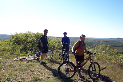
Through a series of rolling hills, we gradually climbed until we came to this overlook. Here was a good spot for everyone to regroup before continuing on.

Tom gives a thumbs-up at the overlook.
From here we rode along a ridge and past the Pine Grove State Forest campground. We eventually came to another overlook, where the group stopped to have a bite to eat.

Emerging from the woods approaching the overlook.

Milling about up top.

Looking out from up top.

Time to change color yet?
After refueling our bodies, we enjoyed a series of fast downhills through a couple fields before heading into the woods again. Once back in the woods, we went through a series of hills. One in particular was of the "you have got to be kidding me" variety.

Rooty, steep, and long meant that we were climbing this one on foot.
The top of that climb brought us to the Shingle Mill Pathway, which we rode for about 6 miles. The Shingle Mill Pathway is actually a series of loops (we rode the western side) that is used as a cross country ski trail in the winter. This meant things were open and fast for 6 miles. This started with a screaming downhill which had us well in excess of 20mph (approaching 30mph at one point). We then rode through some swampy lowland, complete with a long, but thankfully wide boardwalk. We had a couple of short climbs, and ended the Shingle Mill portion at the parking lot near the Pigeon Bridge Campground (regretfully closed this summer due to DNR budget cuts). Here was the spot of the first car, and we took a nice break to eat, stretch, and refill hydration packs.

Boardwalk on the Shingle Mill

Me at Pigeon Bridge. This is where my ride ended during the summer ride (going the other direction).
We left Pigeon Bridge and rode through an open stretch of forest. The trail had a great flow, and some good hills to go down or grunt up. A general uphill trend took us to the location of an old fire tower. The fire tower is gone, but if you search around you will find parts of the old foundation.

At the fire tower site, a good spot to regroup.
From the fire tower, we descended for a bit, climbed a bit, rode a ridge line stretch, and then descended into the swamps again. Here were more boardwalks... a bunch of them. There was one long one which I rode this time. An accomplishment, as I walked the entire couple hundred yards of it in the summer. There was then a few short sections of boardwalk, and a really gnarled section of roots. On one of these boardwalks I went down, HARD. I got some speed, lifted my front wheel to set it on the boardwalk, didn't get my wheel high enough... bike stopped... I didn't! A handlebar/thigh meeting gave me the mother of all charlie horses, and this would twinge when I would pedal (or push my bike). After sitting for a few, I got back on the bike, determined not to let this stop me.
We climbed out of the lowlands, and rode some miles through a stretch of trail that had an excellent flow. This went on for a few miles, until we were spit out onto County Road 622. Here was the second car where we rested, refueled, and prepared for the ride (hike) up Rattlesnake Hill. The climb up Rattlesnake Hill is another of the "you gotta be s^*#ing me" variety. Long, steep at parts, with a loose slope filled with gravel and baby head sized rocks to finish things up. Yep, hike-a-bike fore sure!

Me atop Rattlesnake Hill. You can see for about 20 miles, especially when it's as clear as it was for this ride.
Some of the group on top of Rattlesnake Hill.
We were treated to some fast, and perhaps the hairiest, downhills of the day coming off Rattlesnake Hill. Things became flatter, we had a section through some ferns, another tangle of unrideable boardwalks and roots, some sweet singletrack, before we were ultimately dumped out onto 622 again. Here the crew voted, and we elected to forgo the last couple of miles crossing over M33, instead electing to take the back way into the park. We were getting pretty whupped by this point, and showers, beer, hot food, and stories around the campfire awaited.
Was it a good ride... no, it was a GREAT ride. Was it easy... hell no! Will I be back... hell yeah!

No comments:
Post a Comment